The Sands of Frazier Island
Thursday, November 29th – 0620 – We are up early and ready to leave Lady Musgrave Island to go almost 60nm to Bundaberg, but we still can’t see well enough under the water to spot the bommies. We have to wait for the sun to get a little higher for better visibility before we motor across the lagoon to the reef passage. It is sunny and calm, and after we finally get out of the reef, we have to motor the whole day. Seas are so calm that we can see a turtle 50 yards away. By late afternoon, we are tied up in the Port Bundaberg Marina. Jane Minor, The First Mate’s long time friend, arrives an hour later. Jane is going to sail south with us to her home in Mooloolaba.
Friday, November 30th – There is a fish store just up from the fuel dock. While The Captain is attending to the fuel, the two gals go off to see what the store has to offer. Bugs! “Have we ever had bugs?” Jane wants to know. No, we haven’t, and she tells us we are in for a treat. Her treat, in fact, and she buys us a bunch of bugs for tonight’s dinner.
.

Moreton Bay Bugs are well known out here. The UN Food and Agricultural Organization prefers the name Flathead Lobster, but Bugs are what the Aussies call them.
.

After fueling, we are off to Fraser Island. It is another calm day and once again, with 50nm to go, we are forced into motoring the whole way. This is Jane’s third time on Avante, and with nothing exciting happening under motor, she knows how to make herself comfortable.
.

Stretching over 75 miles, Fraser Island is the world’s largest sand island. We anchor off Kingfisher Bay Resort with about 8 other boats. From Avante, we can see little of the resort other than a large dock for the frequent tourist ferries that drop visitors ashore.
.

That night, we enjoy our dinner of Moreton Bay Bugs on deck. Served with a garlicky butter, they are delicious and will become a sought-after treat on Avante.
.
Saturday, December 1st – We set off to do some touring on the island. Jane has been to this island many times and tells us that the best way to see this island is to rent a 4WD vehicle. If The Captain will drive, she will be our guide. Ensconced in a rugged, no-frills vehicle, we head out on a nice paved road that abruptly ends at the resort boundary. The “road” we find ourselves on consists of two deep ruts through very soft sand. The Captain quickly learns why he was asked to drive!
.

This is like driving through deep, soft snow. One does not want to stop as it would be easy to get stuck with wheels doing nothing but spinning deeper into the powdery sand. Meeting another vehicle is a challenge as the road is narrow and often the sides of the road are at least a foot higher than the ruts. It is a fight to maintain the right amount of speed to keep going in the direction one wants to go.
.
Jane mentions that years ago when she came out here to camp with her family, the sandy roads were not this deep or treacherous, but Fraser Island has now become a popular vacation spot. The island ferries bring cars as well as people, and it is the increased number of cars on the roads throughout the island that has churned up the sand to make the ruts so deep. We just hope to not meet another car coming in the opposite direction or one stuck right in front of us. What a mental and physical challenge this driving is!

Jane directs us to a favorite spot. Lake McKensie is one of many freshwater lakes on this sand island. Its water is clear, cool and brilliantly blue. What a delight to dapple around in this lake after weeks of salty sea water!
.

Grabbing our lunches, we set out along the trail to Lake Wabby. Finding a good spot to sit in the dappled sunlight, we stop to enjoy our lunch.
.

After traversing through dense forest on these soft sand roads, we reach the beach on the eastern side. Here, hard sand forms a firm surface, and we understand now why big red letters taped to the windshield state that the maximum speed on the beach is 60km. The rest of the island is 30km – if one can even manage to go that fast!
.

For those not wanting the ferry ride over to the island, tourist planes now offer them a bird’s eye view and a landing on this firm, level beach. Touring vans then take the visitors around the island to see the sites.
.

This beach is known as one of the world’s most dangerous. There are strong riptides, and the place is a favorite hangout for young Great Whites. During the summer months, marine stingers such as Irukandji Jellyfish and Blue Bottle may be present. None of us are going anywhere near the ocean, but it sure is beautiful.
.

Our next stop is another of Jane’s family favorites: Eli Creek. It doesn’t look like much initially, especially as we hike up a trail along its banks. At the top of the trail, we slip into the creek which is about 2 to 3 feet deep. Lay on our stomachs, we are swept along by the current all the way down to the beach. What a fun adventure! The child hidden in The First Mate could do that again and again, but time is running out for our return of the car by 4:00.
.

One final stop is to the Eurong Resort Store, an island landmark and fixture. Jane remembers many afternoon ice creams here with her kids, and even for us big kids, an ice cream treat at the end of a hot day is just the thing.
.
What an adventure! We congratulate an exhausted Captain who drove us through the treacherous shifting sand roads without once getting us stuck. Having seen another car or two that the sand got the better of, we know that was a feat. Heading back to Avante, we decide to clean up and return to shore for dinner at the resort but change our minds when we get to the dinghy sitting on the beach at low tide. While everything on this island is sand, the shallow bottom just off the beach is oozing, deep, sucking mud. Now at low tide, we have to push and pull The Dingbat for quite a distance until the water gets deep enough to hop on board and lower the engine. It’s a yucky, slurping, very unpleasant trip through ankle-deep mud. We decide that a return trip for dinner is not worth dealing with that goo again.
South of great, sandy Fraser Island lies the Great Sandy Straits which run between the island and the mainland, and they just happen to be in the direction we want to go on our way south to Jane’s home in Mooloolaba. The issue for us is that areas of the straits are quite shallow and will be a challenge for our deep-drafted boat. There is another route we could take, but it means we would have to head north and then go around the top of Fraser Island before we could head south down its 75 mile-long eastern coast with no available safe anchorages. Taking that route would necessitate an overnight passage. It’s the long way around, and who wants to do that? Motoring through the much direct and calmer waters of the Great Sandy Straits will take less time and be much more interesting. If we had a shallower draft, this winding passage would be a breeze. A number of people have told us that Avante’s keel is too deep to get through the Great Sandy Straits. However, others have told us that we can probably get through. Obviously, The Captain likes the challenge.

Sunday, December 2nd – Australian friends, Dian and Ross Jones, upon hearing that we were going to be anchored off Kingfisher Resort and living just a short ferry ride across on the mainland, ferry over to join us for lunch at the resort. While waiting for the ferry to dock, we look down on a beach at high tide. Pretty it is now, but we know what an oozy mess it becomes out there at low tide. Fortunately, we will not have to contend with that today.
.

We had not seen Dian and Ross since Puerto Vallarta in 2010 when we were all getting ready to cross the Pacific. How much fun it was to catch up on our lives, and of course, traveling across the Great Sandy Straits is discussed. With care, they confirm that we can do it.
.
Monday, December 3rd – Yesterday upon returning to Avante after lunch, we moved down Frazier Island to anchor in a bay off South White Cliffs. This will be the spot from which we will head off across the Great Sandy Straits. The shallowest part of the straits is known as The Crossovers where the tide coming from the north and the tide coming from the south meet. The current causes the sand to shift around over time, and our charts will be no help there.
.

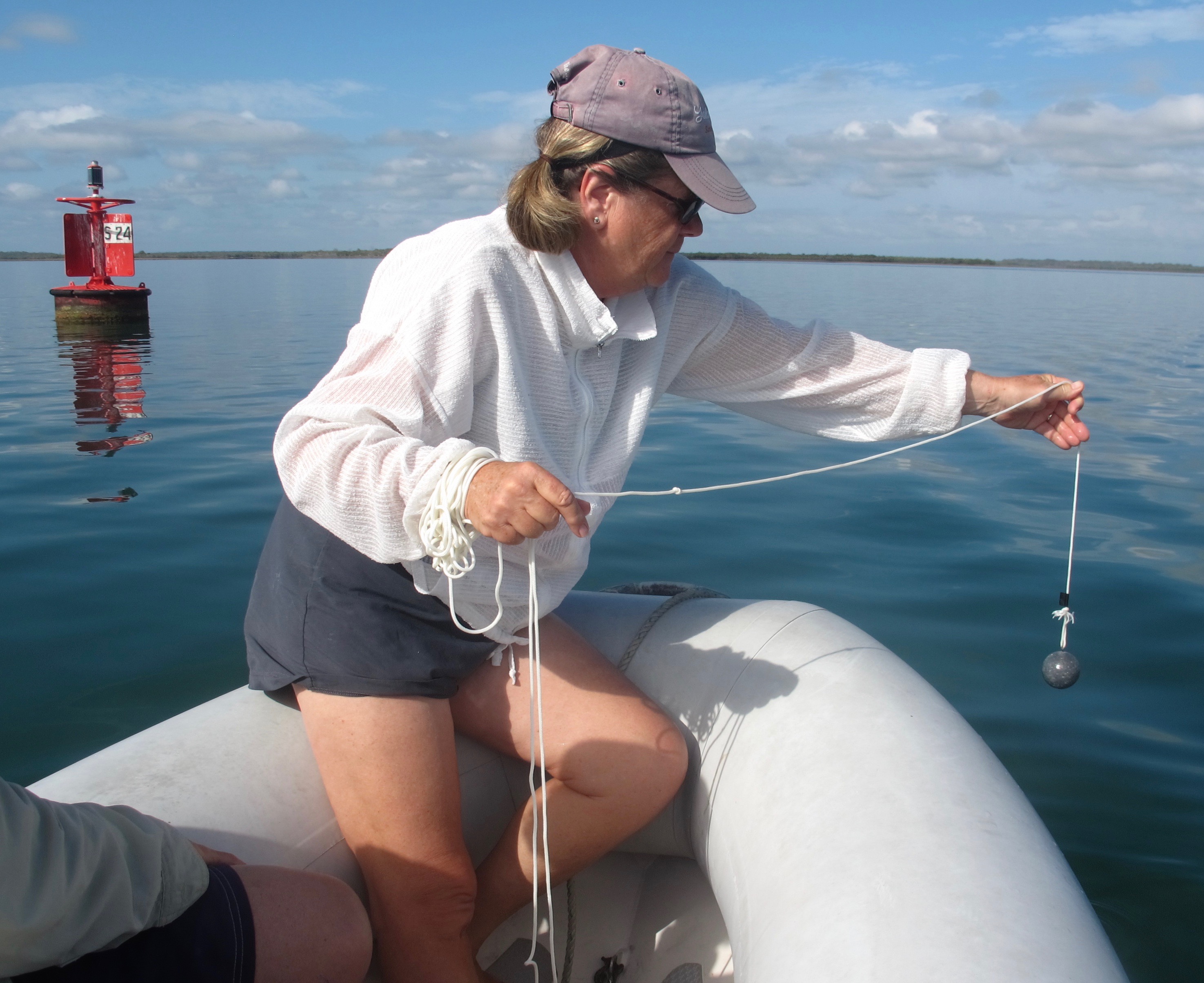
The Crossovers is not far from where we are anchored, and not wanting to take on this area blindly, The Captain has a plan. We are going to head out there in the dinghy to plumb it. To do so, we need a plumb bob to measure the depth from the dinghy to the sandy bottom. Not having one on board, The ingenious Captain fabricates one.
.

Reveille! Reveille! All hands are mustered at dawn to scout out this shallowest section of the strait. We all climb into The Dingbat and head over to this shallow section. The winding course through these shallows is marked by buoys which are moved as the bottom shifts, but there is always a question as to when the channel was last plumbed and how accurate the buoys are at the moment.
.
The Captain motors between the buoys, stopping in a number of locations while The First Mate drops the lead weight from the dinghy to measure depths. Jane records the locations and the depths. The Captain’s objective is to map the contours of the bottom searching for the deepest spots for Avante to motor through safely. When back on Avante, he will use this information to plot the best route through this section and develop notes on how close we should pass each buoy.
At 1030, on a rising tide, about 1 1/2 hours before high tide, we start through this shallow section on Avante. The First Mate is at the wheel while The Captain is directing her and monitoring our depth. A couple of smaller sailboats that had also been waiting, decide that it’s a good idea to follow us, the big guy. If we can make it, they will have no problem. We proceed cautiously, but with a fair amount of current, we need to keep our speed up to keep steerage on the boat. If we run aground here and can’t get off before the tide starts falling, we will be stranded for hours until high tide returns. At low tide, Avante will end up, shamefully and dangerously, lying on her side in the shallow water. We push that thought aside, for with our scouting trip at dawn, we are ready. It seems longer, but after 15 minutes of intense concentration and precise navigation, we reach Green Buoy #27, the end of this shallowest area, without running aground. We all take a deep breath. We have made it through the shallowest section, and the lowest depth we saw was 9.1 feet. Not much clearance, but enough. Bravo, Captain!
Even though we are through that very shallow area, we still motor on cautiously. The smaller boats,which followed us through that area like ducklings after mother duck, no longer need to proceed as slowly. They speed up and pass us waving as they do so. Aboard Avante, we laugh at their antics, but know, too, that with their shallow drafts, we could not risk following them even if we wanted to do so!
Wide Bay Bar at the southern end of Frazier Island is the next challenge. It is the southern entrance to Great Sandy Strait. The constantly shifting sandbar (sand again!) is shallow and often conditions are extremely hazardous. It is one of the most notorious bar crossings in Queensland. When the tide is running against the wind, it can become very rough. We have seen pictures of a sailboat being pushed forward on the face of a wave. Because the bar is fairly shallow, it is necessary for us to cross it at high tide. The course through is identified by waypoints and starts off in the northeast direction staying north of Middle Bank. Then, there is a 60 degree right turn between sand banks to get out into deeper water. The Australian marine authorities are very helpful and regularly update the waypoints as well as maintain visual navigation aides on the shore of Frazier island. They will also provide the latest condition report by radio.
.

Inskip Point is just before Wide Bay Bar, and it is here we drop anchor in the afternoon. We will spend the night here and cross the bar in tomorrow morning’s high tide. For the rest of the day, we watch the ferries pulling right up to the sandy beach to load and unload cars for the trip to and from Fraser Island.
.
Tuesday, December 4th – Winds are blowing 20 – 25 knots from NW in the morning, and we are really bouncing around our anchorage, so there is some concern about conditions out on the bar. After receiving a favorable report from a fishing boat that just crossed the bar, The Captain decides to go. We time our departure to cross the bar just before high tide. We motor through, staying on the course between the waypoints and find plenty of depth all the way and to everyone’s relief, we have no issues. It was a bouncy ride, but that was all.

By 1130, we have crossed the bar and are removing the sailcover to raise the sails. Mooloolaba is still 55nm away, and due to the timing of high tide at Wide Bay Bar, we will be arriving well after dark. The channel into the harbor at Mooloolaba is not very deep. To compound things, there is a notice to mariners warning that the sandbar has moved and dredging operations will be blocking part of the entrance and that there is a temporary buoy marking the sandbar. We are not sure what we are going to meet when we get down there this evening, but we press on.

The sun sets as we are passing Mt Coolum, Australia’s second largest monolith. Wind drops off after sunset, and we turn the engine on.
.

By the time we reach Mooloolaba, winds are back and blowing at 18 – 22 knots, now from SW, and the seas are not calm. We decide not to try to enter a strange harbor at night, especially with the sandbar issues. We anchor off the beach right in front of the city. How spectacular the lights are! Jane can even pick out where her home is located. Out here, it is windy and rolling, but we and Avante are safe. Tomorrow is time enough to traverse that channel into Mooloolaba proper.
.

With its wide expanse of white beach, Mooloolaba is just as impressive in the daylight. We have no problem entering the harbor the next morning in daylight, and we take a berth in the marina for several days. Jane is eager to show The First Mate around her very clean and prosperous hometown.
.

As so very often happens at marinas, our cruising friends, Don and Marie from Freezing Rain are in a nearby berth. What fun to see them! Jane offers to set up a classic Australian barbie for all of us one evening. There in a town park, large and very clean stainless steel barbie stations are available to the public with clean covered picnic tables.
.

We marvel, knowing nothing like this could ever be maintained for and by the public in the States.
.
It has been wonderful having Jane with us on Avante again. How The First Mate would love to spend more time with her in Mooloolaba, but we need to keep going south. New Year’s Eve is coming, and we hear that Sydney has a fantastic fireworks celebration.