To Australia and the Whitsunday Islands
Wednesday, October 31st – It is a fine day as we motor north to exit through the passage opening of Chesterfield Reef. Once safely through the passage, we turn and sail down outside of the reef. It seems unbelievable, but the distances across and around the reef are so vast, that after 5 hours of travel, our last anchorage is just a few miles away on the other side of the reef. We can see the masts of the sailboats that arrived as we departed!
Winds are good, and our speed reaches 10 knots as we sail down the south end of Chesterfield Reef. Our rhumbline course between Chesterfield Reef and Mackay is 250°, but as fate would have it, there are a few hazards in this our most direct path. The Great Barrier Reef lies in the way. Consequently, we set our course 35° south of our rhumbline to go around Great Barrier Reef.
Our good wind does not last. From midnight Wednesday to midnight Thursday, we broke our record for the lowest distance we have covered on a 24-hour passage. Just 98nm!
Friday, November 2nd – An hour after midnight, we turn the engine on and begin a cycle of motoring, motorsailing and sailing depending on the wind which is constantly changing both direction and intensity.
The new AIS system that The Captain had installed on Avante back in New Zealand, springs into life as we close on the “Outer Route”, the major shipping lane which runs along the Australian coast outside the Great Barrier Reef. AIS tracks ships at sea. It really is a marvel. Boats that also have AIS show up on our chart plotter. Size, speed, direction and, most important, closest point of encounter plus time to such encounter are noted. If a boat out there is on a collision course with our boat, the AIS system will start bleeping madly. All commercial ships of a certain size are required to have AIS, and more and more pleasure/cruising craft now have them, too. Usually we can pick up a signal from a large commercial ship at 20 – 30nm, but due to some unknown quirk of radio waves, today we are picking up targets much further away.
Saturday, November 3rd – Wind was from the SE when we left Chesterfield Reef, but its direction has been changing. By dawn on Saturday, it had cycled counterclockwise completely around the compass and is now back to SE. In the early afternoon, we sail south of the Great Barrier Reef and turn northwest to go up the Capricorn Channel between Australia and the reef. We are less then 100nm off the coast of Australia, but we are still over 200nm from Mackay, our Port of Entry to Australia. The weather is less than ideal with overcast, gloom and occasional light rain from the rear. The watch stander hides behind a half-rigged canvas connector between the dodger and bimini to get some protection from the rain.
.

Monday November 5th – In the early morning light of this our last morning on passage, The Captain takes over the watch and discovers that his mainsail has a sizable parting of the seams that occurred at some point during the dark night. Tropical sun has worked its havoc. These are top of the line cruising sails from North Sails, and they are only 4 1/2 years old. We had hoped the sails would last us a few more years, but that does not appear to be the case. The mainsail will have to be patched together until we have the time and are in a place to decide what to do about replacements. If the mainsail is showing thread decay, we know the jib is not far behind.
.

As we near Mackay, we are amazed at the number of ships shown on AIS. Unbelievable! We have never seen so many. These are not pleasure boats or even commercial fishing boats. These are huge freighters and tankers, most of which are at anchor. Some, however, are on the move and causing our AIS system to bleep. Every single one of those red triangles are freighters or tankers.
.
Why are there so many freighters and tankers out here at anchor and not tied up in a harbor somewhere? It is because the Queensland coast is fairly shallow. From miles outside Mackay, we find ourselves in 40 – 60 feet of water. These big ships can easily anchor at that depth. Thus, the Queensland coast near major ports like Mackay and Gladstone are a mine field of tankers and freighters. We are just seeing the beginning of it.
.

The entrance to Mackay looks very commercial with what appear to be coal conveyer belts — coal being one of Australia’s major exports. This is a working port, but we hear (hope) the marina is nice. We are eager to get into the harbor, clear customs, tie up to our berth and call it a day.
.

Just after noon, Avante is tied up at the quarantine dock where we are visited and cleared by Biosecurity, Immigration and Customs. The fuel dock is across from us, and all is new, clean and modern.
.
Once cleared, the marina office assigns us to a berth, and to our delight, we find ourselves next to old friends from the rally we sailed with earlier in the year, Marie and Don, on s/v Freezing Rain. Others are in the marina, too, and Freezing Rain hosts sundowners that evening for everyone. Jan and Jim from s/v Anthem and Kathy and Allen from s/v Pacific Eagle are there. After we left the rally in Vanuatu, they continued on to the Solomon Islands and then the Louisiades Archipelago before reaching Australia. As cruisers do, we compare our tales of travel and travail. After 6 months with the rally, many of the boats have decided to slow down and stay in Australia for a while.
Our first priority is to get our mainsail repaired. There’s a Doyle sailmaker in Airlie Beach, but we need to get an Australian sim card for our phone to contact him. To get that, we must go into Mackay itself. We decide to do our provisioning while procuring a phone and, taking Jan and Jim with us who also need supplies, we rent a car and head into town. Four hours later, we have a working phone and a car stuffed to the gills with food, liquor and people. We look like we’re buying for disaster relief rather than a few weeks of simple cruising
Airlie Beach is 100 miles up the coast. With the help of Marie and Don, we take down the mainsail, trundle it to the car and drive off to Airlie Beach. It’s a nice drive and great to see the countryside. With our travel by sailboat, we end up seeing a lot of coastline and a good many islands, but we seldom have the time to do land travel. The First Mate is enjoying this. Sail is dropped off at the sailmaker. He can sew our sail back together and reinforce any weak spots he sees, but it will take a week. We, of course, are not going to sit in Mackay waiting for the sail, because we can certainly get about by motor and jib. It is decided that we will sail around the Whitsunday Islands as planned then swing in to pick up the sail in 9 days at the Abel Point Marina just off Airlie Beach. We’ll have to consult tide tables to determine when is the best time to come into the marina, as we will not be able to get in or out at low tide. As noted earlier, the Queensland coast is quite shallow, and the deep keel of Avante is going to call for careful planning.
The very friendly sail company owner tells us that there is a manned National Park station up the road with lots of literature and information about the parks around here. We head over there. The First Mate not only wants the information, she wants to find out more about these deadly box jellyfish that supposedly start showing up as the waters around here warm up with the approach of summer. What are these things? How nasty are they? Does wearing long sleeves and pants really protect or should we buy a stinger suit, a full-body, slinky coverup made out of a material like panty hose? What about one’s hands, feet and face? At least sharks can be seen. These box jelly fish are microscopic or just about impossible to see!
Australia is a fascinating country, blessed with some of the most interesting creatures. Wallabies, kangaroos, koala bears — who cannot love them? It also has some of the nastiest, most venomous and life altering ones known on this earth — salt water crocodiles, paralyzing jellyfish, poisonous, stinging plants. Who wants to meet them?
.

The First Mate’s friend, Jane Minor, emailed her a map of Australia. Spoof it may be, but she shivers at the truth of it. She is not taking any chances! Tell her about these box jelly fish whose bite is supposed to be so painful one would wish one were dead already.
.
She learns enough from the Park Ranger. Stinger suits are highly recommended. Wearing long sleeve clothing is not because the little beasties can get up and inside the sleeves or leggings. Stinger suits can be purchased in Mackay. The Captain is totally uninterested. The First Mate decides that recreational swimming is best done around here in a mini-sub.
After 5 days, we are all set to leave the marina at Mackay. Boat is cleaned and provisioned, laundry is done, and friends and family have been “skyped”. We share a good-bye dinner with Marie and Don for they will be heading south to Brisbane as soon as the winds turn while we are heading north to the Whitsunday Islands with the present southerly winds. The First Mate makes a Saffron-infused Fish Chowder, and Marie brings a delicious warm salad of feta cheese, tomatoes and olives. Of course, we exchange recipes.
Saturday, November 10th – We leave the marina at 9:30 under a pearl-grey sky. Winds are light. We motor. We had been told that the area between Brisbane and the Whitsundays is a delightful cruising ground with one island cluster after another, but other than that, we really do not know what to expect. Shortly after leaving Mackay, the shadowy hulks of freighters dotting the horizon are replaced by the purple-grey shapes of islands coming into view. Lots of islands. Not only is it necessary to identify each one on our charts, it’s fun to see so many in every direction.
.

We are headed to an anchorage on the northwest side of Goldsmith Island in the Smith Islands National Park Group. We anchor at 3:00, lower the dinghy and set out to explore. A creek draws us, but other than a sea turtle swimming by and a small shark in the shallows, nothing catches our attention. We head back to Avante.
.
A man fishing in a small boat hails us. He starts to motor over toward us, and we turn in his direction. We stop and chat for a while. Tom is his name. He and his wife have a vacation home on the small island just across from Goldsmith. Would we join them for drinks in a half hour after he cleans the small queenfish that is lying in the bottom of his boat? At first, we are hesitant. The hour is late. It’s now past 5:00, and maybe his wife wouldn’t be as interested in having total strangers show up out of the blue. After the third invitation, we realize that he truly is serious and, finding him to be a very likable person, we accept. Half an hour later, Tom and Kathrun Biggs are helping us pull our dinghy ashore. Tom is a retired doctor. They winter up here in the islands, while the rest of the year, they live in the Brisbane area. In the 1970’s, they lived with their young family in Port Villa, Vanuatu. This was before its independence when Port Villa was a comfortable, prosperous island town under the influence of French money and French culture, not the shabby, rundown place we saw just a few months ago. Our topics of discussion range far and wide. Reluctantly, we must leave, but we promise to contact them when we are in Brisbane in early December.
Sunday, November 11th – A Southerly Buster is expected to bear down on us within the next 24 hours. What, one might ask, is a Southerly Buster? A mighty, get-out-of-its-path windstorm it is, and coming from the south where lies Antarctica, it will bring a chilling drop in temperatures. We need to find a sheltered spot to hunker down for a few days. The Biggs recommend anchoring behind Burning Point on the west side of Shaw Island. So, taking their advice, that is where we head the next morning. It’s not far to Shaw Island.
.

We are anchored early in a very pretty spot under blue skies and sun. We enjoy lunch sitting on deck wondering when this Buster is going to begin. We do not have long to wait. By late afternoon, winds are in the 20’s. Into the evening, 30+ knot winds bear down on us with frequent rain squalls bringing cold and miserable conditions.
.

We are cozy, nestled inside Avante, but The First Mate wonders about the so-called shelter provided by this island. It feels like we’re right out there in the wind, as if the very hillside in front of us is funneling these 30-knot gales right down on us. She learns that anchored here securely in a muddy bed, it is not so much wind protection we have sought. It is protection from the churned-up seas. Remembering passage nights at sea in heavy winds and boisterous seas … no thanks. It’s the fury of a tempest-tossed sea that this shelter behind this island is providing us.
A pretty beach beckons us, but we cannot go ashore. Shaw Island is part of a vast system of National Parks that Australia has wisely and protectively put together. We have a 2-page chart of the whole area detailing where one can go and cannot go, what time of year one can go and cannot go, where one can fish, which fish, when … the data packaged onto these 2 pages is overwhelming. A quick glance is useless. One needs to sit down, grab a cup of coffee, maybe even a stiff drink, and laboriously mull over the information and colorful charts so painstakingly compiled and compressed for one’s understanding of the dos and don’ts of this vast area.
.

We do so and learn that Shaw Island is a bird sanctuary, and at nesting time, it is forbidden to walk the shoreline of the island. This is the nesting season. Consequently, we are effectively marooned on the boat. We see one or two other dinghies on shore, but either they are ignoring the edict, did not understand the 2-page brochure or chose not to even try.
.
Stuck on Avante we may be, but we keep busy. Besides our various projects and activities, we have internet, and we still have to figure out what has gone awry with The First Mate’s Social Security and Medicare registration. Why can’t she get registered just like any other full-blooded American citizen can – and plenty that aren’t? (See The Winds of New Caledonia – 2012 for explanation) We had recently been told that the Social Security Office for the whole Asia Pacific area is located in Manilla, Philippines. They are the ones we need to contact. We do so and receive an email response asking for our phone number. Our Australian phone number is emailed, but we receive no call. We have no number to call them so we sit tight, wait and hope for a call. Meanwhile, the clock is ticking down to the deadline for her initial registration, and there is nothing we seem to be able to do about it.
Tuesday, November 13th – We had hoped to be able to move to a different island today so we could get off the boat to stretch our legs and explore, but with sustained gusts in the 30’s, we stay put. Here, we know we are well anchored in mud and, just as importantly, so obviously are the 5 boats around us. In the late afternoon, Buster appears to be blowing itself out. By early evening, a balmy 12 – 14-knot breeze is wafting over us. There will be a mass exodus tomorrow!
.

Wednesday, November 14th – We wake up to a perfectly clear sky with the sun rising behind the island. Slowly the sky darkens as we sit there quietly on Avante watching the Solar Eclipse. Talk about being in the right place at the right time. We don 2 pair of sunglasses each and watch the spectacle.
.

It takes very little imagination to conjure up what fear this would have provoked in the Ancient Ones. 7:41am on what had started out as a perfectly normal blue-sky morning. A shadow creeps over the land, and darkness descends. It is an uncomfortable feeling even for The First Mate who knows the scientific reason for what is happening!
.
Within minutes of the sun and moon parting, clouds move in to cover what had been a perfectly clear sky. What positively, absolutely phenomenal luck, for those clouds would have totally and completely ruined the spectacle! Timing is everything so it is said.
Shortly, we are underway. Today, we’re going to enter the Whitsunday Island Group. This is a return spot for us. In 1996, we chartered a sailboat for a week to cruise these waters. The trick for us turns out to be remembering where we had gone and what we had seen. Neither of us kept a Captain’s log or First Mate’s blog back then.
.

Zing! A fish grabs our hook at about 11:30. It’s another big guy! Why can’t we hook a nice 2-dinner sized fish? We don’t need to feed everyone in sight, just the two of us. Worried that we may have another 6-hour battle on our hands like the one we endured on the way to Chesterfield Reef (See Just Us and the Birds at Chesterfield Reef – 2012), we patiently try to haul him in. This one will not give an inch. He’s huge and strong. Finally after almost 2 hours, The Captain has him somewhat near the boat.
.
The First Mate is given the rod. She looks down on this grayish white outline of a fish. It has thick lips and a huge mouth and is pasty white on its sides and belly. More ghost than fish is her timorous opinion. If it weren’t for the pull on the line, she would say that it had no substance. But substance it does have, for when The Captain finally is able to slide a gaff behind its gills, this ghostly fish is too heavy for him to lift on board! The gaff just slips through his fishing gloves. He puts down the gaff, takes off the gloves and starts to tie himself in better when a large swell really rocks the boat and sends the gaff tumbling into the water. The Captain helplessly watches as it drifts behind the boat and quickly sinks. Now what? How are we going to get this heavy fish aboard?
We’ve wasted enough time on this thing. We decide to continue on our way and just drag him along with us. The First Mate is actually thinking that maybe a shark might do us a favor. Here’s an easy dinner, laddie, but we are saved further angst and turmoil when the line breaks. Done, over with, that’s it — we decide we have had enough fishing for a while, maybe a long while. The Captain declares that the shallow waters of the Australian coast probably are not good grounds for the fish we like anyway. Fish like Mahi-mahi, Yellow fin tuna and wahoo — they like the ocean deeps. “Could this not be a bit of “sour grapes” wonders The First Mate?
.

As we enter the Whitsunday Islands area, in the distance, one island after another shows itself on the horizon.
.

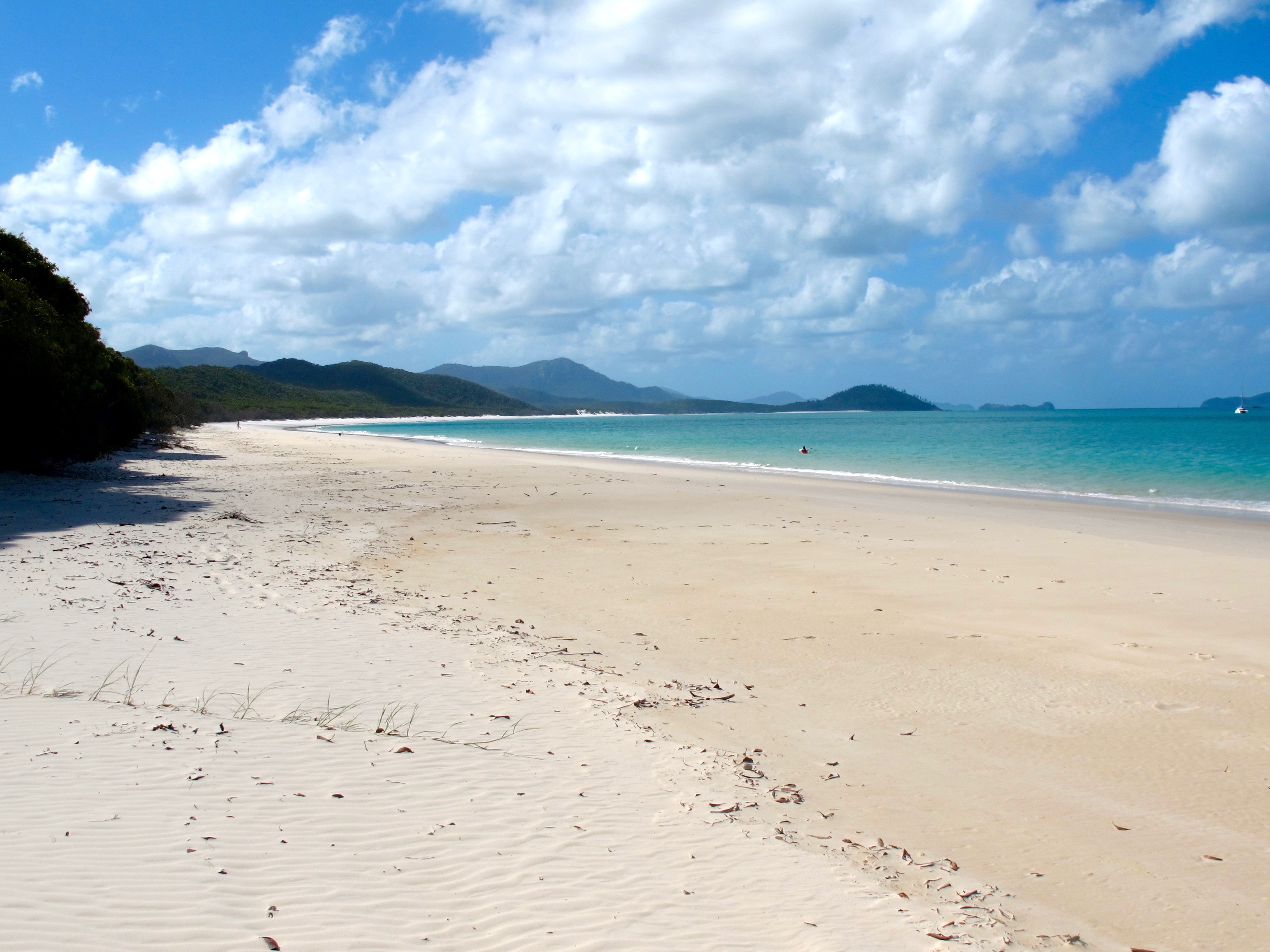
We anchor off famous Whitehaven Beach with a lot of other yachts, tourist boats and sea planes, but this is a must see spot. We dinghy ashore to walk this wide gorgeous stretch of sand, and …..
.

…. because we have anchored as far away from all the other boats as possible, we are able to get a perfect photo of Avante anchored at Whitehaven Beach, Whitsunday Islands, Queensland, Australia, November 14, 2012.
.
We move over to Chalkie’s Beach for the night hoping to be out of the roll of the Whitehaven anchorage, but that is just wishful thinking. At least, we are away from the crowds of Whitehaven. The next day, we stop for lunch at very pretty Border Island and then continue onto Nara Inlet. At the head of this inlet is a hike that takes one up to a cave where ancient Aboriginal paintings can be seen. We slowly motor up the fjord-like inlet with a depth of 29 feet showing under our keel for miles.
.

Anchored far up the inlet, it is hot and still — except for the raucous screeching of large white birds flying among the trees lining the shore. What are they? Cockatoos, we soon find out as a curious one pays us a friendly visit.
.

Launching the dinghy, we pull up on a small strip of beach where a flight of stairs cut into the stone leads us up to where the caves are located.
.

As we climb the hillside, the inlet is seen serenely below us. Avante is that speck of a sailboat just right of center way down the inlet.
.
A sign at the entrance to the cave tells us that this is land of the Ngaro people. We are asked to touch an edged handprint representing today’s Ngaro people and then to proceed down toward the cave following the footsteps of the Ancient Ones.
.

Though the entrance to the cave is fenced off, one can see into the interior where the paintings are visible on the far wall. One cannot help but wonder how old they must be.
.

Protected now by the government, there are many such caves hidden in the hills, and all remain sacred to the people.
.
Friday, November 16th – After one of the quietest and most restful nights we have had in a while, we are up and going by 0800 to get to Abel Point Marina 2 hours before high tide to meet the Doyle sail man who is bringing our repaired sail. We have exactly 4 hours before we must get out of the marina or be stuck in the mud until the next high tide. Such is life in the shallow waters of this Australian coast.
.

We are on time. The Doyle sails rep is on time. The sail is delivered and installed. Cost of repair: one Boat Unit (aka: $1,000.00)
.
We have now sailed as far north as we are going on this trip. From now on, we are headed south and to our delight (“calculated planning” corrects The Captain!), winds are turning to the north. We spend a calm evening in Cid Harbour. It’s one of those quiet dark nights with just a sliver of a moon and the stars bright and big overhead. With the winds now coming from inland and the equator, the temperature is warming up a bit, and we enjoy sitting outside in the dark after dinner.
Saturday, November 17th – After a hearty Captain’s breakfast of eggs and rashers, we set off for the day. An 8 – 12 knot northerly breeze pushes us along as we sail south. We pass another noted Whitsunday spot, Hamilton Island. The First Mate had been wishing we could stop in the marina, spend the night, and go out to dinner at one of the posh establishments on the island, but when we come abreast of the main entrance to the harbor and marina, she is astonished at the development that has been allowed on this once pristine island.
.

She pronounces a monolithic high rise to be shockingly out of place! In retrospect, maybe it isn’t all that bad. It is just the complete surprise of coming on this spread of modernity after cruising for days among islands so assiduously kept as undeveloped, untouched and natural as possible. We pass Hamilton Island by.
.

Continuing on to Thomas Island, the bay we were headed to already had 3 boats in it so we went to a smaller one to the south and have the place to ourselves. It is a delightful spot with a small beach and rocky shoreline
.

We head ashore to stretch our legs and climb those rocks thankful again that, in this crowded world, we are able to find unpopulated, quiet places like this.
.

Avante looks so serene anchored out there in the bay, and everything stays that way for us to enjoy another beautiful evening with dinner under the stars.
.

Sunday, November 18th – We sail into the Cumberland Island Group and anchor at St. Bees which proves to be one of the most impressive anchorages we have chosen. The blues of the water, greens and golds of the hillsides and browns of the rocks are an impressionist’s pallet.
.

We dinghy ashore for a hike up the grassy hillside and are startled by a wallaby suddenly springing up out of the grass and quickly hopping away from us. In this country of strange, new animals for us, that was our first wallaby sighting. Nestled in the tall grass and among the boulders, we are also surprised to find prickly pear cactus.
.

From one side of the hill, we see Avante resting serenely at anchor in the bay.
.

From the other side, we look down and across the many islands that dot Egreement Strait.
.
As evening approaches, the weather becomes more unsettled with 20-knot bullets beating down on us followed by periods of near calm. Sheltered behind the dodger, we are able to enjoy dinner on deck and then watch streaks of lightening above the port of Mackay across the water. A thunder and lightening storm awakens us later that night forcing us to scramble to close windows.
Monday, November 19th – A quick overnight return to Mackay for essentials is scheduled. We pull into our slip at 1015. The Captain mans the hose to wash down the boat. The First Mate runs off to the laundromat. We meet at 1200 and head off in the rental car to provision. We return by 1530 and begin putting everything away. No lunch today, but we do enjoy 2 cold beers. The temperature is decidedly hot. Summer seems to have arrived up here. In between all our running about, we try again to contact the Manilla Social Security Office, especially now that we do have good telephone and internet service. We send them our phone number again just in case they had not received our previous email. Nothing heard. Exhausted after a very busy day, we take the time to relax and enjoy a quiet dinner at one of the local restaurants on the marina quay. Tomorrow, we will continue our trip south, but for now we can sit back and contemplate the quiet serenity and beauty we found in the islands of the Whitsundays and off the coast of Queensland.