2010 Overview – Crossing the Pacific
2010 was a fantastic year for us. We crossed the Pacific Ocean, sailing almost 10,000nm as we went from Mexico to New Zealand. What an incredible trip! Exploring nature in the Galapagos, the rugged beauty of the Marquesas, the strange atolls of Tuamotu, romantic Tahiti, the Kingdom of Tonga, and beautiful New Zealand. It has taken 25 blog entries, some of them long, to describe our adventures and impressions.
At the beginning of the year, we envisioned a four year circuit of the Pacific. We would cross the Pacific getting to New Zealand at the end of the first year, then sail to some more South Pacific Islands and Australia in the second year. In the third year, we would head back across the Pacific from Australia to New Zealand to Tahiti to Hawaii, and then, we would sail back to the Pacific Northwest in the fourth year. However, we have thoroughly enjoyed our first taste of sailing around the South Pacific. It has some of the most interesting cruising in the world, and we are not leaving anytime soon.
.
.
Year End Summary
| Dates | Places | Miles |
| Feb 27 – Mar 19 | Mexico | 260 |
| Mar 20 – Apr 5 | Mexico to Galapagos | 1771 |
| Apr 5 — Apr 17 | Galapagos | 0 |
| Apr 17 – May 3 | Galapagos to Marquesas | 3070 |
| May 3 – Jun 23 | French Polynesia | 1372 |
| Sep 2 – Sep 30 | French Polynesia | 378 |
| Sep 30 – Oct 15 | French Polynesia to Tonga | 1467 |
| Oct 15 – Nov 11 | Tonga | 282 |
| Nov 11 – Nov 17 | Tonga to New Zealand | 1059 |
| Nov 17 – Dec 6 | New Zealand | 44 |
| Total Year | 9703 |
.
.
Before leaving Mexico and embarking on our big Pacific crossing, we did a little bit of sailing near Puerto Vallarta to make sure the boat was all set and to allow our boys to sail with us before we got too far away from home for them to easily visit.
We departed Mexico in March and sailed to the Galapagos, and it took us 17 days to go the 1771nm from Puerto Vallarta, Mexico to Academy Bay in the Galapagos. We had a crewmember with us who wanted to see some of the coastline south of Puerto Vallarta, so we stopped at some of our favorite spots between Puerto Vallarta and Manzanillo for the first 4 nights. On the 5th day, we headed offshore, but for several days, we were in an area south of Manzanillo and off Acapulco known for light winds. We sailed when we could make decent headway, but we did have to run the engine a bit. Then, we began to feel the effect of the Tehauntepec winds. They were blowing 40 knots just off the coast at Tehauntepec, but we were 300 to 400nm away, and the winds were a manageable 20 to 25 knots. Because of our distance out to sea, we were able to use these infamous winds to sail nicely for 500nm before running out of wind as we entered the ITCZ (Inter Tropical Convergence Zone). For the last 4 days, we motored over half the time due to light winds. We crossed the Equator on Easter Sunday, then had to slow down to arrive in daylight the next morning.
The Galapagos Islands are not on the normal route from Mexico to the South Pacific. The First Mate pushed for this 1800nm detour because she really wanted to sail around these islands. Unfortunately, we found that there are many restrictions to visiting the Galapagos with your own boat. Rules for cruising boats in the Galapagos change regularly. During 2010 on a normal cruising permit, you were only allowed to visit one of three designated harbors and were not allowed to sail to any other islands. We spent the better part of two weeks anchored in Academy Bay on Santa Cruz Island. We picked Academy Bay since it seemed easier to arrange tours from there. The First Mate had arranged a private tour, but this got to be too expensive when some people cancelled, so we ended up doing day tours out of Santa Cruz. We do not recommend these. The guides were not the best, and inter-island transportation on pangas was pure torture.
Academy Bay was not a great anchorage, and the boat was hot and constantly rolling. There was a water taxi service as you are not allowed to leave your dinghy at the dock. We made the mistake of having them come to our stern where we normally board our dinghy. Despite having fenders off the stern, our transom received several scars from the water taxis due to the heavy wave action. The other mistake we made was to put up our boat awning that rests over the boom. This provided additional shade and probably made the boat a little cooler. However, when we took this down at the end of our stay, we found quite a bit of chafe damage to our sailcover. Provisioning in Santa Cruz was adequate. It was the usual island routine where you went several times to all the stores and found half of what you wanted. Fueling was another experience. They bring tanks of dirty fuel out to your boat by panga, then try to pump it aboard using some very crude equipment. One breathes a sigh of relief when the fuel panga finally pulls away without having blown himself up. We used an agent in the Galapagos, and he proved to be quite helpful and reliable.
The Galapagos are a natural wonder, but tourism has increased dramatically. The jobs this has created have brought a number of Equadorians to the island, and unfortunately, they have brought their living standards with them. The main street is not bad, but wander one block away, and you find front yards full of liter. The Galapagos are worth seeing, but going there in your own boat is not as attractive as it once was. The best way to see the Galapagos is to fly there and get on a small, high quality tour boat for a week. You see more of the interesting places and have the best guides.
The passage from the Galapagos to the Marquesas was our longest passage ever at 3070nm, and we completed it in 16 days. The wind averaged 20 knots for the first part of our trip, and we had a number of 200nm days. Our best day was 239nm. This was our first leg on what cruisers commonly call “The Milk Run”, and we appreciated the steady downwind conditions. The passage was long, but was uneventful and generally enjoyable. The only bad weather was occasional squalls. During the first part of the trip, the swells were steep, choppy, close together and confused giving us a bouncy ride. This was probably due to the South Equatorial Current coming from a different direction than the wind. That current did help our progress though.
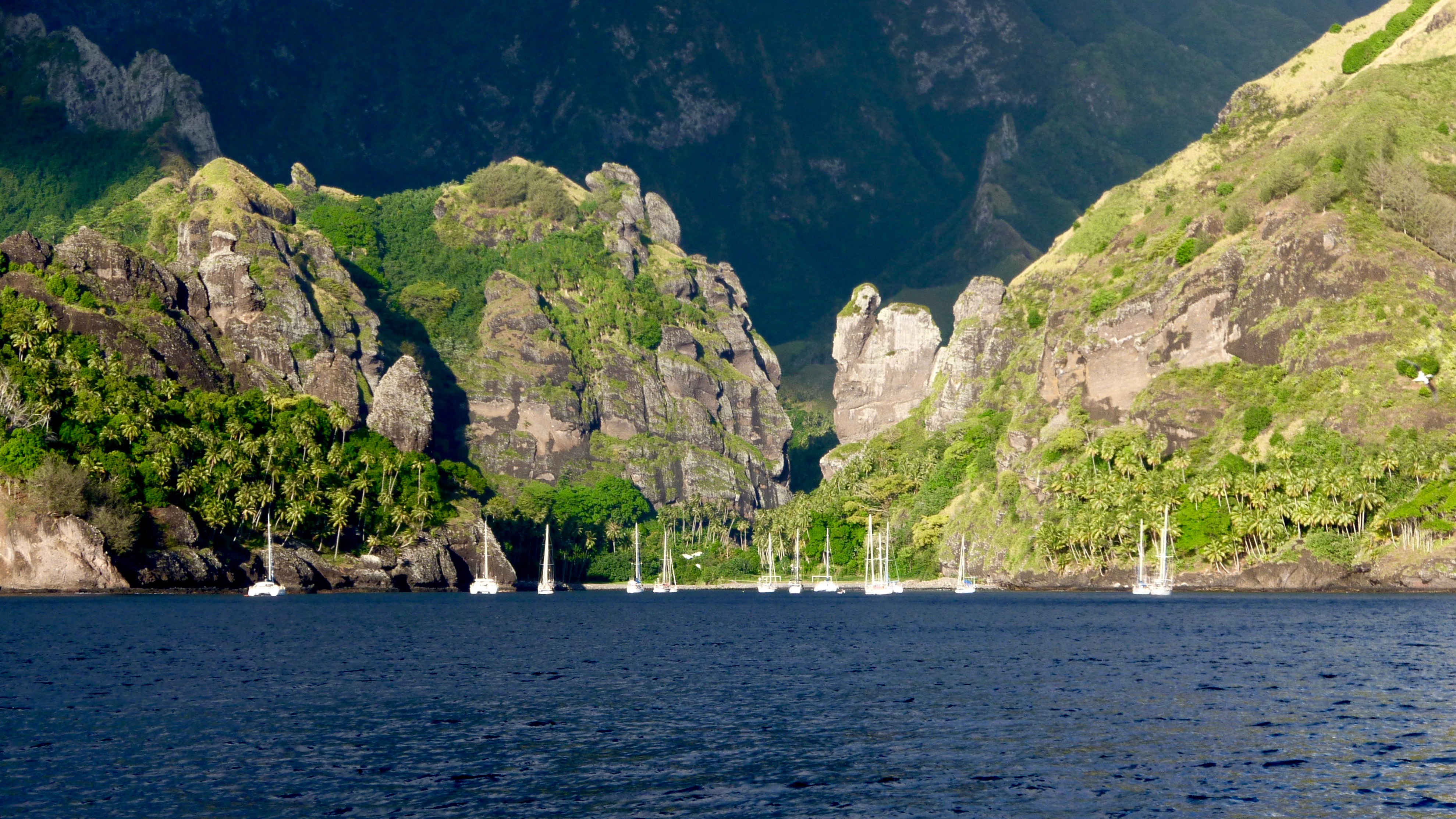
The Marquesas were our first South Pacific Islands, and they are one of our favorites. They are beautiful and dramatic with green vegetation and steep mountains. There is not much tourism here, and the people are very friendly and keep their island neat and clean. Sailing between the islands is easily done in a day, and the charts are good. It’s a great place to start your South Pacific cruising. We first went into Atuona on Hiva Oa to clear in. We also did laundry, a little provisioning and saw the Paul Gaugin museum. We were eager to begin exploring the islands, and after 2 days, we left for a great sail back upwind to Fatu Hiva via Tahuata. For the next several weeks, we sailed to a number of anchorages and visited all six major islands. We finished up with Ua Huka, Ua Pou and Nuku Hiva.
May is the time of year that most cruisers go through the Marquesas, and Paradise gets a little crowded. We could not stay in the inner anchorage at Atuona as it was full. There were 20 to 25 boats in Baie Vierges. There were at least 40 boats in Baie Taiohae, but it is a big anchorage and can easily handle that many. Fortunately, it was far less crowded at the other locations. Our favorite anchorages were Baie Vierges, Baie d’Anaho and Baie de Taioa (Daniel’s Bay). Each of these had great hikes. We spent almost three weeks in the Marquesas, but in retrospect, it was not enough. We could easily have stayed two more. We loved the unspoiled beauty and the friendly people, and the Marquesas are on our list of places to go back to.
From the Marquesas to the Tuamotus was a relatively short passage of 558nm. It took 3 ½ days and gave us a little bit of everything. Winds were light for the first two days, and we had to motor a bit. Then they began increasing. On the last day they were 20-25 knots with heavy seas. We bounced and rolled along at about 8.5 knots with an occasional wave getting under the dodger and dousing the companionway. The Tuamotu Islands are atolls, and we could not see them until we got within 9 miles. They are an incredible contrast to the Marquesas.
We only spent 10 days in the Tuamotu Islands and visited just two of the many atolls. This was way too short! We had planned to visit three atolls, but after analyzing weather forecasts, we decided to skip the last atoll, or we would have no wind for our passage to Tahiti. We had tickets to fly home from Tahiti, and the schedule was getting tight.
The two atolls that we went to were Kauehi and Fakarava. Fakarava was a favorite of a lot of cruisers. We first anchored north by the town for a few days and then south by the pass. These atolls are all about water. Favorite activities are visiting pearl farms and snorkeling or diving. A drift snorkel through the south pass of Fakarava was our highlight. Navigating around inside the atolls was a little bit of a challenge as the atoll lagoons were not well charted, and one had to keep a good lookout for coral heads. Going in and out of the passes required watching the tides, but the ones we went through proved to be relatively tame for us after the Pacific Northwest. There are over 40 inhabited atolls in the Tuamotu Islands, and a number of them would be good places to stop. If we get there again, we would increase the amount of time we allowed and would try to visit 4 atolls.
The trip from the Tuamotus to the Society Islands is a relatively short passage of 250nm, and it took under two days. We had decent wind for all but the last few hours of the trip. Had we stopped at another Tuamotu atoll as planned, we would have had to motor the entire way as the wind died for the next week. Because we were a few days early arriving at Tahiti, we took the opportunity to go around the south side of the island and stop at a few anchorages before heading to Papeete. Not many boats do this, but we found these anchorages peaceful and quiet, and we enjoyed some remote spots on the beautiful south coast of Tahiti.
Papeete is not everyone’s favorite city, but we docked right downtown and enjoyed the experience. It was fun to be in a busy city again. Provisioning was good, and there were a fair number of marine services available. Papeete is where you officially check into French Polynesia. We had an agent and the process was easy.
After Papeete, we sailed to Moorea and spent several days sailing around this island. Moorea is a very beautiful and scenic island, but the tourist industry is long past its prime, and the infrastructure ashore was very disappointing. Many of the hotels and restaurants were closed and appeared abandoned. We finished our trip at the Marina Vaiare on Moorea where we left Avante for two months. There were not a lot of non-local boats at this small and quiet marina, but our agent lived in Moorea, and he arranged for us to keep our boat there. The other option would have been to keep the boat at Marina Taina on Tahiti. Marina Taina is much larger and has services and better provisioning nearby.
Avante looked pretty good when we returned to Moorea in early September. We cleaned her up a little, then we headed for Papeete where our agent had arranged for us to purchase some badly needed new batteries. Unfortunately, these batteries turned out to be much bigger than we had specified, and they would not physically fit in the boat. After searching the island for batteries, we ended up spending over $2000 for truck batteries that we knew would only last for several months until reaching New Zealand. This was the first of several boat maintenance problems that we experienced on our return to Tahiti. We had to sail from Moorea to Papeete a total of three times and spend over 10 days in Papeete getting parts and having a sail repaired. The solutions to our maintenance issues were expensive and not ideal, but they got us going. It was frustrating, but French Polynesia is the best location between the USA and New Zealand to try to fix issues with your boat.
It was almost 3 weeks before we finally departed the Papeete area for the Leeward Islands. This put a little bit of pressure on our schedule for we needed to arrive in New Zealand by the end of November to avoid the cyclone season. The First Mate called our trip through the Leeward Islands “The Bora Bora Dash”. We visited Huahine, Raiatea, Tahaa and Bora Bora. We found these islands beautiful, but like Moorea, they all appeared past their prime. When we had planned this trip to the South Pacific, the Society Islands were the ones we knew something about, and they were at the top of our must see list. They were truly beautiful, but they were not the highlight of our trip.
Our next big cruising destination was Tonga. However, there are 1500nm of ocean between Bora Bora and Tonga. The widely scattered Cook Islands are on the way. These are a strange collection of islands. Although named after the great navigator, Captain Cook, he did not name them. He named all the good places after his benefactors to ensure funding for the next trip and gave no name to the Cook Islands as a group. They are fairly widely separated and do not have many good harbors. We left Bora Bora planning to stop at two of them – Raratonga and Palmerston.
Our biggest surprise during this year was the weather in the Pacific Ocean. We did not always find blue skies and gentle trade winds in the tropics. The issue with the passage through the Cook Islands is that it is almost all in the ITCZ. That means rain, and we had plenty of it. Here are some log entries
- “Winds are 30 to 35 knots. Skies are overcast, and it is raining most of the time.”
- “Continuing to sail downwind under only a partially furled jib with the hatch cover closed. This is definitely not the most fun we have ever had sailing.”
- “Has turned into a dreary day with clouds and rain. We are below most of the time and are trying to use the canvas hatch cover to keep out the rain. The watchstander periodically sticks their head outside to keep a lookout, but visibility is often so poor that we have to use radar.”
After 2 days and about 60% of the way to Raratonga, we updated the weather forecast and learned that they were now forecasting rain and strong winds from the north when we expected to arrive in Raratonga. That harbor is supposed to be unsafe when there are winds from the north, so we decided to skip it and changed course direct for Palmerston. After about 750 miles, we arrived there on the 5th day.
We almost missed the Cooks entirely, as conditions on our arrival at Palmerston were too rough in the anchorage to stay there. We actually continued past Palmerston, but later that day, the winds dropped off to nothing. This had been forecast to happen before our Palmerston arrival, but the light conditions were late in arriving. We updated the GRIB files, and they forecast light winds for the next several days. We were not excited about motoring on to Niue, so we turned around and sailed slowly back toward Palmerston. We would stop in the Cook Islands after all.
Palmerston is a small island that is extremely isolated from the outside world. There is no regular transportation service to the island, and the island supply boat only stops there every 6 to 9 months. We didn’t really trust the moorings. The winds were not very strong, but they were blowing us toward the reef which was very close. We tied up to two moorings and also dropped our anchor before heading ashore. (The following year, a boat was lost when a mooring broke loose.) It was interesting to see this island where everyone is interrelated. They are all the descendants of a Scotsman who settled there in the 19th century with three wives. Palmerston Islanders go out of their way to welcome cruising boats. Cruisers who have stopped there with a number of other boats early in the year have reported good experiences. However, we were the only boat there and were late in the year. Our experience was less than great. We got the feeling that our hosts were tired of visitors by the end of the season and just going through the motions. The meal that they served us was fish heads and sea birds.
From Palmerston to Niue was a relatively short passage of 425nm. Weather was benign, and we enjoyed three days of relaxed downwind sailing. Niue was a very interesting stop. The only harbor is a roadstead off Alofi where there are moorings. You dinghy ashore then use a lift by the stone dock to take your dinghy out of the water and store it on the dock. If the wind and swell are from the west, this is quite an adventure. This island is geographically unique, as it is all limestone with lots of caves. We rented a car and toured the island, stopping to hike to a number of these caves. The rock formations are fantastic, and because there is no runoff from rivers, the water here is very clear. The most disappointing thing about the island is the large number of abandoned houses. Apparently, many of the islanders have gone to New Zealand in order to find jobs. The First Mate’s biggest regret of the year is that we did not spend more time in Nuie.
Nuie to Tonga was an easy passage of 260nm, and it took less than 2 days. We left Niue on Wednesday afternoon so that we would arrive in Tonga before the weekend when it is difficult to check in. Unfortunately, we had not read about Tonga’s unique time zone of +13. Tonga lies well east of the dateline, but they have advanced their calendar to be the first country to welcome the new day. So, it was Saturday morning rather than Friday morning when we arrived. We were advised that they are pretty laid back in Tonga, so we just headed to a nearby anchorage to wait until Monday when customs and immigration officials were working. When we did check in, it was an experience. We tied up to the dock, and it took over 4 hours to get all the officials down to the boat where they were given the expected soft drinks and cookies. Nice people, but very laid back.
Tonga is three groups of islands – Vava’u in the north, Ha’apai in the middle and Tongatapu in the south. We arrived in Vava’u and cleared in at the town of Neiafu. Neiafu has a large and well-protected harbor with plenty of mooring buoys available. It has several shops for provisioning and some nice restaurants. A number of expats live there, and it is very friendly place for cruisers. The cruising is easy and nice in Vava’u. Moorings has a charter operation there, and they have published a chart which identifies most of the potential anchorages by number. The total cruising area is not large, and it is easy to go from one side to the other in a day. There are only a few hazards to watch out for, and most of the water is nice and deep. Unfortunately, it was quite rainy during the last half of October in 2010, and that did restrict our activities a bit. There are a couple of anchorages where you need to be able to see the reefs, but when we went near them, the sun disappeared, and the winds picked up, making it impossible to see the reefs.
Our schedule got a little easier here when things changed, and we no longer had to sail on to Fiji to meet crew for the passage to New Zealand. While we accomplished a lot this year, both of us felt that we had not scheduled enough time to visit many of the islands. The detour to the Galapagos and our summer months in Telluride limited our time available. Also, we had not fully anticipated the time we would spend having maintenance done, the time it took to clear in and clear out of these island nations, the time required to provision in many of the places, and the amount of time we would just stay on the boat during poor weather.
Next, we sailed south to the Ha’apai group. There is some great cruising here, but there are a lot of hazards in the water, and the charts we had were not that accurate. Our biggest restriction here was that our anchor windlass had recently failed. To avoid having to lift a heavy anchor and an all chain rode without a windlass, we switched to our backup anchor rode which had only 25 ft of chain and 175 ft of rope. We tried to anchor in shallower locations, and we dove on the anchor to make sure that there was no coral nearby. During one of these dives, we found a wrecked boat on a nearby reef. We later learned that the boat had been lost less than a month earlier when their anchor dragged.
The southern group is Tongatapu. For most cruisers, the only stop here is at the town of Nuku’alofa and the nearby anchorage at Big Mama’s. The harbor in Nuku’alofa was small and a good walk from town. There were several stores to provision at, but they were located all over town. We hired a taxi to provision and ended up having our driver take us on a tour of the island. Tongans are friendly and quite large. Our taxi driver, named “Tiny”, had been recruited to play football at a college in the United States. Big Mama’s is a small resort on a nearby island with a beach, dock, and restaurant bar, and it is run by a large Tongan woman. Except on weekends, most of the customers were cruisers. The anchorage is decent, and it was filled with cruising boats. If you made a movie about cruising in the South Pacific, you would design a set similar to Big Mama’s.
Our focus now was on the passage to New Zealand. We fueled, provisioned, and completed the necessary paperwork in record time. However, when we were ready to leave, it was Nordhaven weather. We do not carry enough fuel, nor did we have any interest in motoring over 1000nm, so we had to wait five days for some wind. There were a number of other boats spending time at Big Mama’s waiting for a weather window, and we got to know a lot of our fellow cruisers. The place was classic, and it made the wait enjoyable.
When the wind finally arrived, over 20 boats departed for New Zealand in one morning. However, the winds came with far more gusto than forecast. They were a comfortable 15 to 20 knots on our first day, then they increased to 25 to 30 knots. The wind was from the east to southeast and well forward of the beam. The ride was bumpy and wet, but we made good progress covering 600nm in three days. When we were 350nm north of New Zealand, we ran out of wind and had to motor for most of the rest of the way. We completed the 1050nm passage in just under 6 days, and it was certainly our most difficult passage of the year.
New Zealand is a sailing nation and has some wonderful places to sail and numerous competent marine services. We went into Opua in the Bay of Islands where we cleared in with customs and immigration and got a slip in the Opua Marina. We ordered a new windlass motor from the chandlery shortly after our arrival, and the correct part was there in two days. There were all kinds of knowledgeable and capable marine services nearby. Avante was going to like this place! We had not done any major work on the boat since we left the United States two years before, so it was time. We were going to pull Avante and leave her in the boatyard at Opua while we went home for almost 4 months, so there would be sufficient time to get a lot of maintenance completed. We spent several weeks arranging for work to be done and doing a little cruising in the Bay of Islands. We loved New Zealand, but we had spent many months on the boat this year, and the holidays were approaching. We left Avante on the hardstand in Opua Marina and flew home in early December.