Great Barrier Island

Wednesday, April 10th – It’s almost 100nm to Great Barrier Island from the Bay of Islands, way too much for one day, and since the idea of an overnighter is not enticing, we decide to head south down the coast to the pretty harbour of Tutukaka (don’t you just love these Kiwi names?). We head out at 0830, and by 1000, we are approaching Cape Brett. We cut between the mainland with the Cape Brett Lighthouse overlooking the point and a massive offshore rock called Piercy Island.

Over the last several years as we have sailed across the ocean to clear into New Zealand here in the Bay of Islands, it is for Cape Brett that our eyes eagerly search. After a week or more alone out on the ocean, this headland, though seen tiny and hazy in the distance, means we are almost there. Land Ho! Just a few more hours to go to safety and a full night’s sleep.
.

Nearing the entrance to Tutukaka, a sailboat is seen approaching from the south. The Captain recognizes the boat. It’s Kim and Zim on s/v Someday, a boat we had met in Fiji’s Lau Group last season. We knew that they were heading north to the Bay of Islands to get ready for their passage back to Fiji this year, but we did not expect to meet them here. How wonderful that we will get to see them before they leave! We quickly drop our dinghy from its davits and head over for a visit.
.

Thursday, April 11th – Leaving the sheltered anchorage of Tutukaka under patchy grey skies, storm clouds are bearing down on us. With occasional bursts of sunlight, rainbows appear, but there’s no bright rainbow’s end for us. Soon those heavy grey clouds are overhead, and we are hunkered under our storm cover as rain pelts down on us.
.

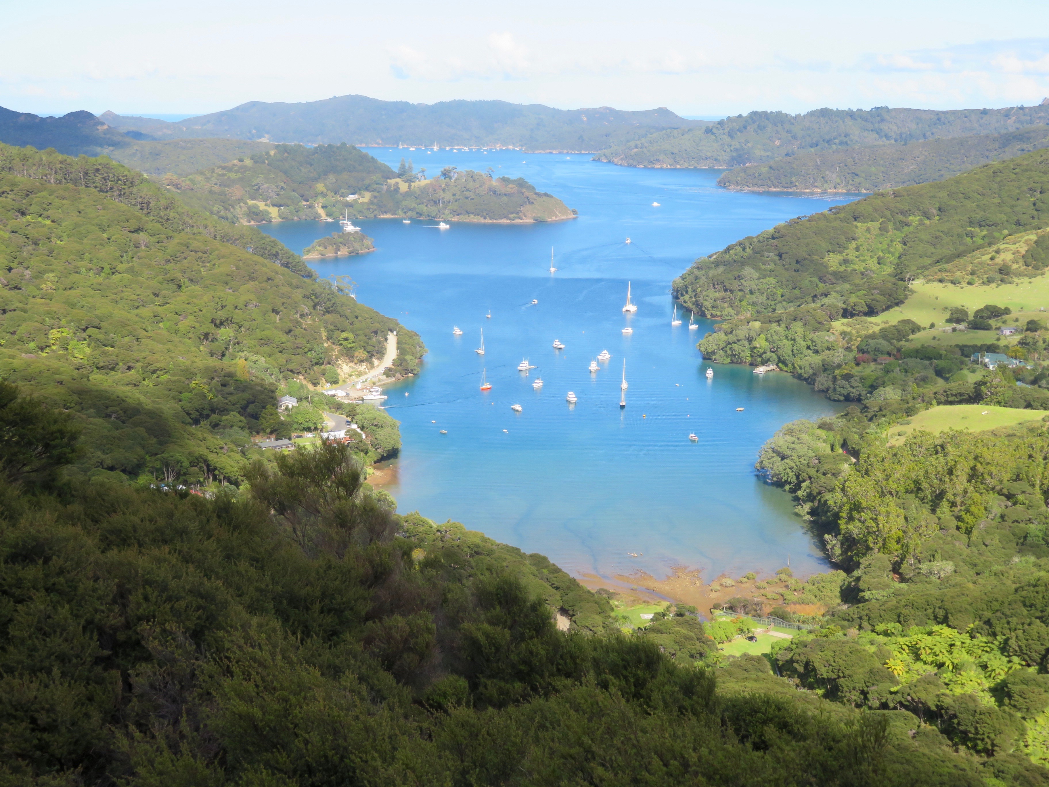
By 1500, Port Abercrombie on Great Barrier Island is ahead of us, but with its wide, open expanse, it offers no shelter from the heavy storm winds or the rough seas until we near the passage connecting with Port Fitzroy. Through the passage, we are now in more sheltered waters, and we drop anchor behind Kaikoura Island. It’s not a pretty anchorage, but we’re just happy to be anchored and getting ourselves settled for the evening.
.

Across the Pacific, we have found special spots created specifically with cruisers in mind or were put together by cruisers for other cruisers. Most often they are rustic, quaint, fun and ever so welcoming. Here on Great Barrier Island, another cruisers’ hangout is found. It’s called Smokehouse Bay, and yes, there is a rather large smokehouse for the many fish caught in these waters. There are wooden tables and benches, a real Pizza oven, a great tree swing for the kids and a small beach for summer bathing. This spot was one man’s dream. He bought the land, fought the codes to have it built and then gave it to the government to be conserved. Donations from cruisers keep the place going. Intrigued, we head ashore to explore.
.

There is even a bath house with a wood fired stove for heating water.
.

Inside the shed is a white porcelain tub. The place is spotless. On the stove outside, water is being heated up for the next bather. The First Mate is not at all sure this would be her idea of a nice “bubble in a tub”, but the spirit of the place certainly amuses her. Smokehouse Bay attracts many cruisers, especially in the warm summer months, with it rustic charm and inviting amenities for young and old alike.
.

Sunday, April 14th – A popular hike on Great Barrier is the trek up Mt. Hobson or Hirakimata as the Maoris called it. With huts for overnighters, it brings in many who ferry over from the mainland. We did this hike in 2015 and are eager to go out there again, for in 2015, the Kaiaraara Track had been closed due to a land slide. This track takes one past an old Kauri dam that we are eager to see. We anchor in a bay not far from the Akapoua Campsite shown at the top left corner of this map and hike over to the start of the Kaiaraara Track. This we will follow to the top of Mt. Hobson shown way on the right side about halfway down the map. On the return, we will follow the trail to the Mt. Heale hut and then the South Fork Track (dotted line) back to where we started. Lunches packed, we take off for our 6-hour hike.

A detour off the main track leads us to one of the old Kauri dams. These dams were built during the height of the cutting down of the great Kauri trees. The dams were built across a steep and narrow part of an upland river. As the water built up behind the dam, cut Kauri trees were floated in the waters. When a significant amount of water and logs were behind the dam, a specially constructed hinge was pulled to open the dam. Word is that the sound of the water and logs rushing through the canyon was like thunder reverberating for miles in all directions. These dams were amazing feats of engineering built by logging men with little engineering experience, but great as they were, little remains of the intricate structures after almost 100 years.

An uphill body The First Mate has never had. Downhill, she can keep up with the best of them, but uphill, she’s a snail. Today’s exertion, however, is ridiculous. She’s exhausted, spent. The Captain tells her that shortly, he is sure, we will intersect the trail coming up from the Mt. Heale hut. She can go down there to wait for him while he goes to the top.
Did she really hear him say that? Giving him her most withering look, she ignores him and silently plods on. She has come this far. She may feel like a 100-year old Galapagos tortoise, but a quitter she is not. Never! Besides, this is much too steep. He is wrong. We have to be nearing the top.
.

And we were. Not exactly around the next bend or up the next steep section of stairs, but we were closer to the top than expected. The view from up there is magnificent, and if it were not for about 25 teenagers from an adventure cruise ship anchored below who were perched on the tiny viewing platform, it would have been truly grand!
.

Stairs and more stairs on the way down, but these she sees are not as steep. Some even require 2 steps per tread to traverse. It must be said that both the engineering and the labor that went into building these stairs are impressive, and the stairs are sturdy and strong with nary a wobble!
.
We stop at the Mt. Heale hut to eat lunch and admire the view. From here, we will follow the South Fork Track on our return. It is so named because nearer the bottom, it follows one of the rivers coming down from the mountains.

The only slight issue we have on the return trip is finding the yellow trail marker poles along the river bed. We know that at some point the trail is going to leave the river bed, and we must make sure we do not miss that turn, for not far after that turn, the river bed becomes impassable. The trail cuts back and forth across the river several times requiring one to gingerly and carefully test each stone while crossing the river. A loose stone could give one a wet foot or worse, a twisted ankle. The First Mate is sure this is something we should not be doing at the end of a long hike on exhausted legs, but we have no choice. It’s onward, but at least it’s not upward!
Not 6 hours, but 8 hours it took us (mainly her) to complete that hike. She is upset with herself, but on the return trip, her opinion of the climb up was confirmed. The Kaiaraara Track is steeper. It is not longer, as in her misery she so thought, but that steepness gives forth to longer and more vertical uphill climbs or, in other words, several hundred more steps.

Monday, April 15th – Klaus, a German friend of ours whose cruising path has crossed ours several times in the last few years, is nearby at anchor this morning on his boat s/v Julia. On his dinghy, we motor out to take a photo shoot of Avante with our dinghy on her very new davits. The Captain will never approve of how it all looks, but to The First Mate, it is all an eye-catching, functional and practical beauty.
.

A quick visit with Klaus, and we are off to one of our favorite anchorages, Whangaparapara Harbour, on the SW side of Great Barrier. Heading out through Man of War passage, we motor through an area called Broken Islands so named for its many rocky islands, several of which look like they were once connected.
.

Whangaparapara is a pretty harbour with mountains looking down on it that remind The First Mate of the Bay of Virgins in the Marquesa Islands. The view out from the shore is peaceful, and The First Mate only wishes she were child enough to take a ride on that swing. We spend several days here mostly relaxing with a few short hikes thrown in for diversion.
.

With a change in wind direction, we move over to Rapid Bay on the southeastern side of the harbour. We had not anchored here before and, to our surprise, find it gives us the feeling of being more remote. That night, the full moon puts on a brilliant display for us.
.
One of our objectives here on Great Barrier is to circumnavigate the island as we had done in 2015, but the winds don’t cooperate. Instead, with a 5-day Easter Weekend approaching and the anticipated increase in boats coming over from the mainland, we decide to return to Port Fitzroy where its many bays give us multiple anchoring options. Plus, the internet strength is far better over there, and The Captain wants updated weather information.
.

Saturday, April 20th – Port Fitzroy has a small store, and after 2 weeks, we could use a few provisions like milk, eggs and whatever fresh veggies they might have.
.
The Captain, as one may have ascertained, is not a great salt water fishing aficionado. Give him a fly rod and a mountain stream any day. The First Mate is not a great fan either, but she is enamored with the idea of putting wild game on her table. She announces that she is eager to try a new recipe: whole snapper in a foil packet with herbs and wine cooked on the barbie. For that she needs a really big snapper or 2 of legal size will do. Off they go in the dinghy with an unenthusiastic Captain aboard, for she is not prepared to handle rod, fish, motor and dinghy on her own.

The snapper are biting, but all we get are little ones or ones just temptingly short of legal size. What we do attract, however, is a shag or, to be more correct, a pied cormorant, the most tame of its species and a most brazen opportunist.
.

It pokes its head under water below our rod. It dives on our line, swims down to the hook. Is it going to bite the hook, and are we going to have to un-hook a fighting mad bird? No, this guy is smart enough. He’s just waiting for a dumb fish to bite.
.

We do catch a fish, and that bird is flapping around us. Is it going to attack us or the fish? We flap back at it. Shoo! Get out of here! This is our fish, but the fish is just a bit too small for legal catch. The Captain unhooks it and prepares to throw it back. Eyeing that bird eyeing the fish, he tries to slip it in the water, but that bird is too fast. Down it swoops and out it comes with this fish in its mouth. Too big for it to swallow, he will not let it go either.
.

While engaged with his “catch”, we hook another fish. To our dismay, our bird friend drops the previous fish to flap on back to us. Reeling it in, The First Mate can feel that this fish is too small to meet the legal size limit, but she’s determined that that bird is not going to get it either. We’re not fishing for him after all! Yes, the fish is too small. We unhook it. She’s watching that bird, flapping back at it, waving and shouting at it and feeling utterly ridiculous. Meanwhile, off the other side of the boat, The Captain surreptitiously slips the fish into the water. Faster than a lightening bolt, that bird sweeps over us, dives into the water and comes up with “his” catch. In less than a blink of the eye, down the gullet it goes. We’re amazed. That fish was longer than that fish’s neck. How did he do that? What kind of stomach does he have? That fish was still alive! Wow! We now figure that our friend has at least a 2-week meal in his belly. He’ll lumber off to digest his gorging and leave us alone.

But he does not leave us alone. He’s back for more! How could he even fit another fish in that belly? Another fish is caught. A bigger one this time, but still not up to legal size. Short of doing aerobatics in the tippy boat, The First Mate does everything she can to distract the bird. The Captain decides that perhaps throwing the fish as far out as possible might give the fish a fighting chance. No joy! That predator is too fast, but this time he’s stymied. Attempting to fly away with his prize, the weight of the fish in his mouth and the one swimming around in his stomach stall him in mid flight. Fish is dropped.
Unperturbed, he returns to us. Finally, we hook a fish that is of legal eating size. Into the bottom of the boat it goes with us watching warily that the bird doesn’t attack the fish or us. A second good-sized fish is caught. We’re off. Out of here, away from that bird and back to the boat.
Note: Whole baby snappers stuffed with scallions and lemon slices wrapped in tin foil (al-lu-mi-ni-um, as it’s called here) with a healthy splash of white wine added before the packet is sealed, cooked on the barbie, is delicious — maybe even worth the fight we had to get them!
.

Sunday, April 21st – Mother Nature gives us a treat today. We went ashore to hike Old Lady Track. The Captain thinks this is an appropriate name for one of its hikers. The First Mate does not. On the way up the track, a sign to Lookout Rock causes us to detour. From the top, a great view of the bay below Port Fitzroy opens up below us.
.

Both the hike up Lookout Rock and this Old Lady Track are narrow, rocky and almost overgrown with brush. The steeper parts are slippery with loose dirt and pebbles. We grab ourselves makeshift walking sticks to steady us along the way.
.

As we motor out from the dock at Port Fitzroy, we notice that an unusual amount of dinghies are circling around in the bay. All onboard appear to be scanning the waters. What is going on? Whales, we are told. A pod of orca whales is swimming around the bay. We join the group scanning the waters as eagerly. Is Mother Nature going to put on a show for us? She does! For over an hour, we follow this group of whales as, ignoring us, they cruise along the shore line feeding in the late afternoon. We have seen whales before off the deck of Avante, but never have we been out in the dinghy and this close to them. We keep our distance, for they are way bigger than we are and totally unconcerned by our presence, but still we slowly follow them out the harbour.

From the summit of Lookout Rock a wide expanse of land that looked to be a cattle farm had caught our attention. It was visible across the inlet from the Port Fitzroy dock. There weren’t that many cows roaming about, but with the several buildings all looking substantial and in very good shape and with extensive fencing and well maintained green lawns, we think it must be the estate of a gentlemen or hobby rancher. There is a dock below the land with a large sign on it. Curious, The First Mate had requested an inspection. This isn’t a private farm. The sign states that this is a reserve called Glenfern Sanctuary.
Back on the boat, she googles this place and discovers that it is open to the public, no reservations needed, and that the Glenfern Loop Track takes one around the whole area through a fern-filled glen to an ancient Kauri tree. Glenfern Sanctuary was the dream of one couple, Tony and Mal Bousaid. They bought the land in 1992. Both land and buildings had fallen into disrepair. They spent years restoring both. An avid conservationist, Tony began revegetating the land and constructing an impressive fence running across the peninsula to keep out predatory animals. Over the years, both native vegetation and endemic birds are coming back to the area. The land now is run as a trust and fully dedicated to conservation for the future. We are going to explore this place.

Monday, April 22nd – Mid afternoon, we motor to the Glenfern Sanctuary dock in our dinghy. Nobody is there, but then we have never seen anybody or any dinghy tied up to this dock. Climbing ashore, we follow the path up. Crossing below the homes that are now used for accommodations, we are impressed with them and their peaceful setting. Opening a gate, we enter the bush. It’s a magical place which well deserves its name of Fernglen. Ferns are everywhere growing along the stream that we will be following up the trail. Some are so tall that they form umbrellas over our heads.
.

The trail is wide and well-maintained. We note young Kauri trees growing deeper in the bush as we walk past ancient, gnarled Puriri trees along the path.
.

With frequent rains and the heavy overhead foliage that blocks out the warmth of the sun, the old wooden stairs are sometimes slippery with green moss, but little does that detract from the serene beauty of place.
.

We had read that there will be a hanging bridge that will take us across to an ancient Kauri tree, but we did not realize that this bridge ended directly at the tree. The experience of being so up close and personal to this ancient beauty is truly awesome.
.

To our amazement, we look up to find that a viewing platform has been built among the branches. We can touch the tree, experience its rough bark, wonder at its age and strength. Looking up, we can see its branches growing far above us.
.

Looking down, we marvel at how high up we are. It’s a long way down there!
.

A slight detour takes us to Sunset Rock. This must have been a favorite spot of Tony Bousaid, for a commemorative placard gives testimony to his conservation foresight. We also can see from the view down across his land and to the water below why this may have been special for him. The First Mate would have loved to sit longer, but it is nearing 4:00, closing time, and we still have to make it down to the water and dock.
.
Wednesday, April 24th – We had planned to leave today to sail back to the mainland, but yesterday, The First Mate made a suggestion that truly startled The Captain. “If we delay one day, I would very much like to climb Mt. Hobson again,” she quietly said. Did he hear that correctly? “What was that,” he queries. “Climb Mt Hobson,” she says. Her desire is to make the summit in reverse of what we had done 10 days ago. Let’s go up what in her imagination is the longer, more gradual South Fork Trail and down the shorter, steeper Kaiaraara Trail. She had not been able to find a stair count for this trek, but she is positive there are more stairs up the Kaiaraara Trail than up the South Fork Trail. She wants to prove to herself that she can do it as she remembers doing it 4 years ago. In addition, she wants to enjoy being on the summit without being crowded out by a group of gawking teenagers. He agrees to the delay and happily to another hike.
.

Sandwiches and water bottles packed, we set out in the early morning. Reaching the South Fork Track, we start up the river bed. This time we both grab a sturdy stick to use as added balance across the often slippery rocks.
.

There are many suspension bridges running across the deep gorges on both tracks to the summit. This one swinging above the tree canopy is one of the longest and definitely the narrowest.
.

A sign at its entrance gives the hiker pause. Achtung! (The First Mate’s input) “Maximum Load 1 Person” One person? “Why?” one might reasonably ask. Upon crossing, she figures out why. Each step causes the bridge to wobble and vibrate. Another person following would create another wave of discordant movement making each step a challege.
.

Feeling not at all secure and holding on tightly, she does stop a moment to let the vibrations and swinging her steps were causing subside. A quick peak over the wire top to look down is cautiously tried.
.

A break in the dense brush gives us a view of Mt. Hobson on the left and Mt. Heale on the right.
.
We stop at the Mt. Heale hut for a snack of oranges. A family is there with a teenager who knows the answer to The First Mate’s stair question. A teenager? They, of course, know everything, and she takes his word as truth. There are over 1,100 steps on the South Fork Track and a mind-numbing 2,200 steps on the Kaiaraara Track. Both reach the same summit. Her body is vindicated. It had a right to be so exhausted on their climb 10 days ago. The Kaiaraara one is definitely steeper and thus from her non-uphill body perspective, much harder.
.

The summit at last. Though she broke no speed records going up, she made it as she remembered she had 4 years ago. What a relief and joy that was! How glad she is she suggested we climb Mt. Hobson again! With just a few people on the platform, we take our time surveying the view down and across the distance.
.
What a great last day on Great Barrier Island! Tomorrow, we begin our journey back to the mainland and eventually up to the marina in the Bay of Islands. There we will do our final preparations for our next passage. It’s on to New Caledonia we are in a few weeks.
Comments (2)
Joyce Allred
You two are clearly overjoyed to be back at sea, and love your many adventures! I take my hat off to you, it sounds like a great adventure!!!! Happy sailing, and hurry home! Ron & Joyce
Libba Anderson
FABULOUS pictures and commentary. What adventures you continue to experience year after year. thanks for sharing – see you in a few months. Safe sailing!!