The Inland Waterway
Let it be known that The First Mate does not patiently endure excessive heat and soggy humidity. It’s not just a matter of temperament. It’s that her body, in particular her skin, does not like excessive heat and soggy humidity. Growing up on the east coast of the US with beaches within walking distance, her friends spent blissful summer months out there soaking up the sun. Not her. One day out in the sun, and a hive-like prickly heat rash would erupt. “Sun poisoning”, she was told. She later learned from a Mayo dermatologist, after a vicious outbreak on a Caribbean holiday, that it is a UV sensitivity. Nothing can be done about it. “Stay out of the sun”, she was told. She does stay out of the sun. Well, mostly she does, but experience has taught her that sun alone is not the culprit. The lethal combination for her is sun coupled with over-heating and high humidity. Nobody does well in those conditions, but she seems to suffer more than most. She has learned ways to lessen the severity of the rash attacks, but she can do nothing about how the rest of her body reacts. Her face will break out into a sweat which stings and irritates as it dribbles down into her eyes, and though not sunburned, she will feel like her skin is on fire. Add in a flu-like feeling of unwellness and a low-grade headache — well — anyone’s outlook would be ruined.
She remembers the first time we came to Australia. It was in February, 1996. We chartered a boat for a week of sailing in the Whitsundays. Dumb idea. Think Key West in August. It was unimaginably hot and drippingly humid with hardly a breath of air. We both suffered. The Captain’s lips swelled up and cracked while The First Mate developed angry hives up and down her arms and across her chest. Fever blisters ravaged her lips. So bad was her state upon returning to the dock, it was mentioned that a trip to emergency might be a good idea. Instead, she was placed under a cold shower and then into an air conditioned car. Anything to bring her body temperature down. Revival was slow, but it happened.
She also remembers a time in January 2012 anchored in Lane Cove, Sydney Harbour, with Telluride friend, Jane Hardman, a guest on board. It was an oven-hot drippy day with not a breath of air. No one wanted to wander ashore. The three of us spent the afternoon in a zombie stupor. Jane in her cabin. The Captain stretched out in the salon, and The First Mate on their berth. No one spoke. No one moved. We endured until a slight cooling signaled that early evening had arrived. We still shudder when any of us recalls that day. “Never again,” she said.
Yet, here she is. January — in Australia — heading down to Sydney. It is said that some people never learn. Yup, she is defiantly one of them. Experience teaches not!
 Tuesday, January 10th – We arrive in Brisbane in the middle of a summer heatwave. As the reality of her situation hits, The First Mate kicks herself for her stupidity. What is she doing here again in this heat and humidity? What ever was she thinking? Nothing to do but grin and bare it, neither of which does The Captain think she does very well.
Avante has been docked in Raby Bay, a fantastic canal community south of Brisbane, where our friend, Stephen, has a home, a dock and a sister ship to our J/160, Salacia. Stephen’s neighbors have an empty dock, and they were kind enough to offer us their dock while we were back in the States. Upon arrival, we are pleased to see that Avante is in good shape and needs little work to get ready to sail. It is a good thing that she doesn’t need much work, for even The Captain, who normally is more tolerant of heat than his cranky First Mate, says that it is too hot to work on the outside of the boat past 8:00 in the morning.
We take 2 days off to visit Jane Minor, The First Mate’s grade school friend, at her home in Mooloolaba overlooking the ocean. Catching up and waxing on as only old friends can do, we enjoy an evening together with The Captain a tolerant listener. There’s a Costco, that bastion of US shopping know-how, located on the way back to Brisbane. Jane had not been to a Costco in Australia and maintained that this is not the way Australians shop. For the experience, she decides to follow us. 10:00 the doors opened. 10:10 we are there. The parking lot is full, and so is the store. Astonished at carts the size of small Fiats overflowing with goods, Jane concedes that Australians have indeed learned to shop the Costco way. We stock up with wonderful veggies and fruit, beautiful meats and a few prepared dinners for the two passages ahead of us. There are even bagels which are hard to find anywhere out here in the Pacific. A package of smoked salmon is added to the cart. Bagels and lox for breakfast . Yum! We go our separate ways after checking out of Costco but not for long. Jane will be joining us in Sydney in less than 2 weeks.
 We enjoy our time in Raby Bay, catching up with Stephen and Pamela and sharing a few days with his daughters and granddaughters. They are a heart-warming family and full of Australian hospitality. Here we are enjoying a roast pork dinner with sinfully delicious crackling, a treat we seldom see now in the States, though remembered well from our childhood years.
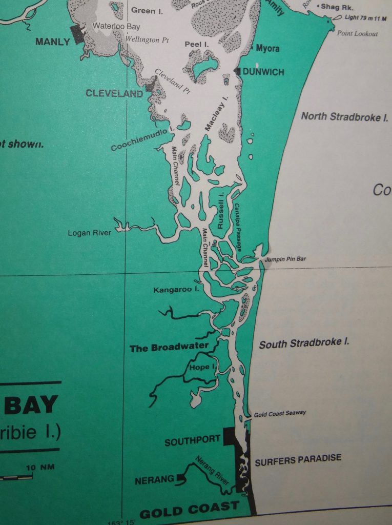
From where we are, there are 2 ways to head south. We can retrace our track back up Moreton Bay past Brisbane, going around the north end of Moreton Island out into the ocean and then turning south, or we can exit Moreton Bay to the south to follow the Inland Waterway winding down to the Gold Coast. From there, we would cross the bar and head out to sea. The First Mate opts for the Inland Waterway. For her, it is more interesting and means less time out on the ocean (wimpy sailor that she is).
Tides are an issue when following this inland passage, as it is quite shallow. There are several low spots, and we on Avante must clear them on a high tide. Though there is no worry of rocks or coral reefs, getting stuck in the mud is no fun either. This will not be our first testing of this channel. The very first time we motored down it not only did we have Stephen riding along as guide for part of the trip, we were blessed with a King Tide that occurred at noon giving us perfect timing to cross the low spots – provided we did not dawdle. This time, with the tide not as high or opportune, we are not so lucky. After analysis and discussion of the tide tables by Stephen and The Captain, The Captain puts forth the idea of doing the waterway in two stages rather than one long sweep. Stephen considers that a sound idea, and though he had never done it that way, he knows a possible anchorage for the night.
Monday, January 16th – Our route south is chosen. We will do the Inland Waterway in 2 stages. With a short first day ahead of us, we cast off the lines in the late morning and head out of Raby Bay into Moreton Bay. Both of us are delighted to be back on the boat and setting off on another adventure. After a gentle passage across the southern part of Moreton Bay, we start down the first part of the Inland Waterway. This area, though shallow, is benign. Mostly we have to watch out for ferries crossing to and from the various outer islands.
By mid afternoon, however, we reach the first tricky section heading south on the Inland Waterway. It is descriptively called the “‘W”. Beyond it lies our destination for the night. There is no problem with depth here as long as one stays in the narrow channel while making the turns of the “W” as indicated by the placement of the green and red poles. Here, red poles stay to the right. Green poles to the left. Twice we abort our entry into the corridor when ferry boats are either overtaking us or coming from the opposite direction. We just don’t want to be pushed wide of the channel by a fast moving, large ferry unaware of our nearly 9’ keel. Finally, the path is clear, and we motor around the turns carefully and easily. Once through, we turn off the waterway and cross a wide bay to drop anchor north of Karragarra Island just outside a field of boats on mooring balls. We are amazed at the current running here. Even with a stiff wind blowing, the boat is being pulled opposite the wind by the intensity of the current. One certainly wouldn’t want to go swimming off the boat here without a rope to hold onto, but neither of us is enticed to get in the water. With the muddy bottom, the water is brown with the fine particles churned up by the current. It just does not look inviting, but, alleluia! the breeze is cooling things down.
Tuesday, January 17th – 0915 – We have most of the shallow challenges of the Inland Waterway ahead of us today. The most critical one is south of a small settlement called Jacob’s Well. Though it has been known as being very shallow, our experience three years ago led us to conclude that this area must have been dredged. Nonetheless, this section determines the timing for our trip, as The Captain wants to cross it on a rising tide and no later than one hour before high tide. We raise our anchor and retrace our track to where we turned off the waterway yesterday afternoon.
This Inland Waterway between Brisbane and the Gold Coast is a relatively flat area protected by barrier islands. Several small rivers empty into this area creating a complex maze of islands and water. On a chart it looks like there are several arteries that we could take to get from north to south. In a small powerboat, it would be fun to explore the many passages, but Avante’s deep keel, which is an asset in the ocean, is a real challenge here. We have little flexibility in our route, and we always like to have a rising tide in case we run aground.
 Going through the Inland Waterway is different from other areas we have been on Avante. For most of the trip, it feels like we are navigating a meandering, slow-flowing river. The navigable corridor of grey spidering though the green on this map to the left holds no rhyme or reason for us as we slowly motor across the shallow sand and mud bottom. Sometimes it nicely runs straight down the middle of the channel. At other times, it makes an abrupt turn to head directly toward shore, and then, improbably, it will run right along the shoreline with a huge expanse of water off to the side of the boat that though it may look inviting, is too shallow. Unlike many places we go, the water color gives no clues regarding the depth. It is all a uniform murky brown color. The channel is charted and has navigational markers to guide us, but, with shifting sand, the bottom does change over time. Caution is the guide word.
 The shoreline on this section of the Inland Waterway is densely lined with salt water loving mangroves. Where the spits of sand are shallowest, they have found a foothold spreading out into islands of green. At times, we find ourselves carefully motoring down a passage narrowed by mangrove shores on both sides, and even with the thrumming of the motor, we are aware of how quiet and still the world is here.
 At other times the water opens up into a sizable bay, but one where you must still be very careful to stay in the channel. Navigational markers generally show the way, but sometimes they are far apart. Being on the proper side of the channel markers does not necessarily mean that there is enough water for Avante. Though we use the depth information from the charts to stay in the deepest sections, our eyes are constantly on the depth gage. 8.7’ is the critical number for us. Any lower than that and Avante will be stuck in the mud.
 Small, remote communities of vacation homes nestle along the shore as we slowly proceed further south. With the shoreline itself so shallow, rows of docks run out from the land. This is an area where shallow draft boats rule. A few sailboats can be seen, but the predominant boat is a motor boat with the flat-bottomed one or two-story houseboat, the Winnebago of the water, being the most popular.
 At one point, there are so many boats moored ahead of us that we are not sure where the channel goes until we get closer. Though most are commercially produced, we see a good many that are obviously DIY, and many we see are in dire need of TLC. Along this section of the Inland Waterway, a true mishmash of homes, boats and lifestyles can be seen.
Finally, the sky scrapers that mark the beginning of the Gold Coast pageantry can be seen hazily taking shape in the distance. We have entered the beginning of the long strip of shoreline called the Gold Coast. After the quiet and peace of the last 2 days, civilization hits us smack in the face. Yet, even here as we motor through this tremendously built-up area where the waterway is wide and open, the deeper channel we must follow is narrow and winding. We zigzag on getting closer to a shoreline choked with one massive house after another.
 No, this very symmetrical edifice pictured here is not a hotel or other commercial enterprise. It is a home.
 With little in the way of trees or other vegetation to add contrast and definition, we find this display of architectural boldness stark and uninteresting.
 As we get closer to the Gold Coast, landscape companies have made an impact, and the homes look more inviting with trees and green vegetation. Lots appear to be larger. Maybe that’s just the trees, but there is definitely a feeling of more breathing room between the homes. Here, canals wind inland off the main channel with an occasional mast rising above a roof line. We speculate that this section must be older than the concrete and water landscaped one we had just passed.
Approaching the commercial, high-rise populated city of Gold Coast, we decide to forgo the entertainment-packed shore we anchored off of last time. Amusement rides and seaplanes hold no interest for us. Instead we do an about-face to motor left off the main channel into a smaller one. Here, where it will be quieter, we anchor at 1430. It has taken us over 5 hours to motor just 20 miles! This anchorage may be quieter than the one we had used previously, but throughout the rest of the afternoon, we are amused by 2-person paddle boats and wind-surfers while speeding motor boats and jetskis rock us to and fro. Such is the beautiful, extravagant Gold Coast.
Now the question forming to be asked: Did we go aground on our passage down the Inner Waterway? To our chagrin, it must be admitted. Yes, not once, but three times we struck mud. The cause of the first event is open to debate, though by mutual, unspoken consent, The Captain and The First Mate have chosen not to continue along those lines. Such is not healthy for marital bliss aboard s/v Avante. The First Mate insists that The Captain told her to turn 10 degrees right when he meant left. Coming up from the Nav Station below, facing her as she stands at the helm, his right is opposite her right. Twice he told her to do so and did not catch that the boat was turning in the wrong direction. The Captain, on the other hand, insists that The First Mate’s brain anomaly came into play. How many times has she turned right when he said left? Twice she did as she thought she was told and never caught her error. Or was it her error? His error? It is here the debate stops, not to be further pursued or mentioned.
The second time we were motoring down the channel, passing along several green markers and giving them quite a bit of clearance as we passed. Suddenly, the depth meter reading dropped from 10 ft to 8.5 ft, and Avante stopped abruptly as it slid into the mud. The chart showed adequate water here, but obviously, the bottom, shifting sand that it is, had changed. Revving up and backing out, we found deeper water further to our right and continued on.
The third time was definitely The Captain’s fault. (His words spoken here, for The First Mate would never dare be so definitive.) Motoring nicely down a fairly deep (18 – 20’) part of the channel, we came to a section where the channel bent right. At the bend, a smaller waterway was seen merging with the main one we were following. At the point of merger, there was a marker in the water. Neither red nor green, The Captain assumed it was a special marker to indicate the beginning of the smaller waterway. The First Mate was instructed to pass the marker on our left. That she does, and seconds later, the depth meter unwound. We were going too fast and plowed into the mud to an abrupt embarrassing stop. Ugg! The First Mate quickly reversed, but though we were moving around our stuck point, the depth stayed resolutely at 8.3’. 8.7’ is our break free number. The Captain took over, and finally by maneuvering forward and backward, the depth meter crept up to that magical 8.7. We break out of the grip of the mud and float free. As we motored around the other side of that strange marker, The Captain realized that it was a cardinal marker indicating the boundaries to a shallow area.
In retrospect, we started too early on this second day. The shallow sections south of Jacobs Well that determined our timing were not as shallow as charted. We had almost 6 feet of clearance when we crossed them an hour before high tide. On the other hand, we had less than a meter of water below the keel much of the first 10 miles of our trip, as the tide was only about halfway up. Had we waited another ninety minutes before starting, we would have had a lot more water on that section and a lot less trouble.
The Inner Waterway is behind us. We are positioned to head out the Gold Coast Seaway in the morning and then south to Sydney. The latest wind forecast, downloaded before starting out, will be the determining factor. The Captain has been closely monitoring the weather forecasts for the last several days and has been dismayed by how often the forecasts have been revised and changed. Unsettled and flukey is all we can call this weather. Fortunately, we will have the current with us on the trip south, so it is only a two day trip. If departure, however, must be delayed by an adverse weather window, The First Mate does not mind. After all, we are just cruising with no particular place to go and no particular time to be there.